


Precision Mapping Technologies Transforming Modern Agriculture
By 2024, GPS-based land surveying has become a dominant force in agricultural planning, with over 80% of large farms employing it for precise field mapping and layout design. In contemporary farm management, surveying extends far beyond boundary measurement. It encompasses detailed analysis of soil composition, terrain features, hydrological elements, and infrastructure placement, all of which underpin resource allocation, crop planning, and environmental stewardship.

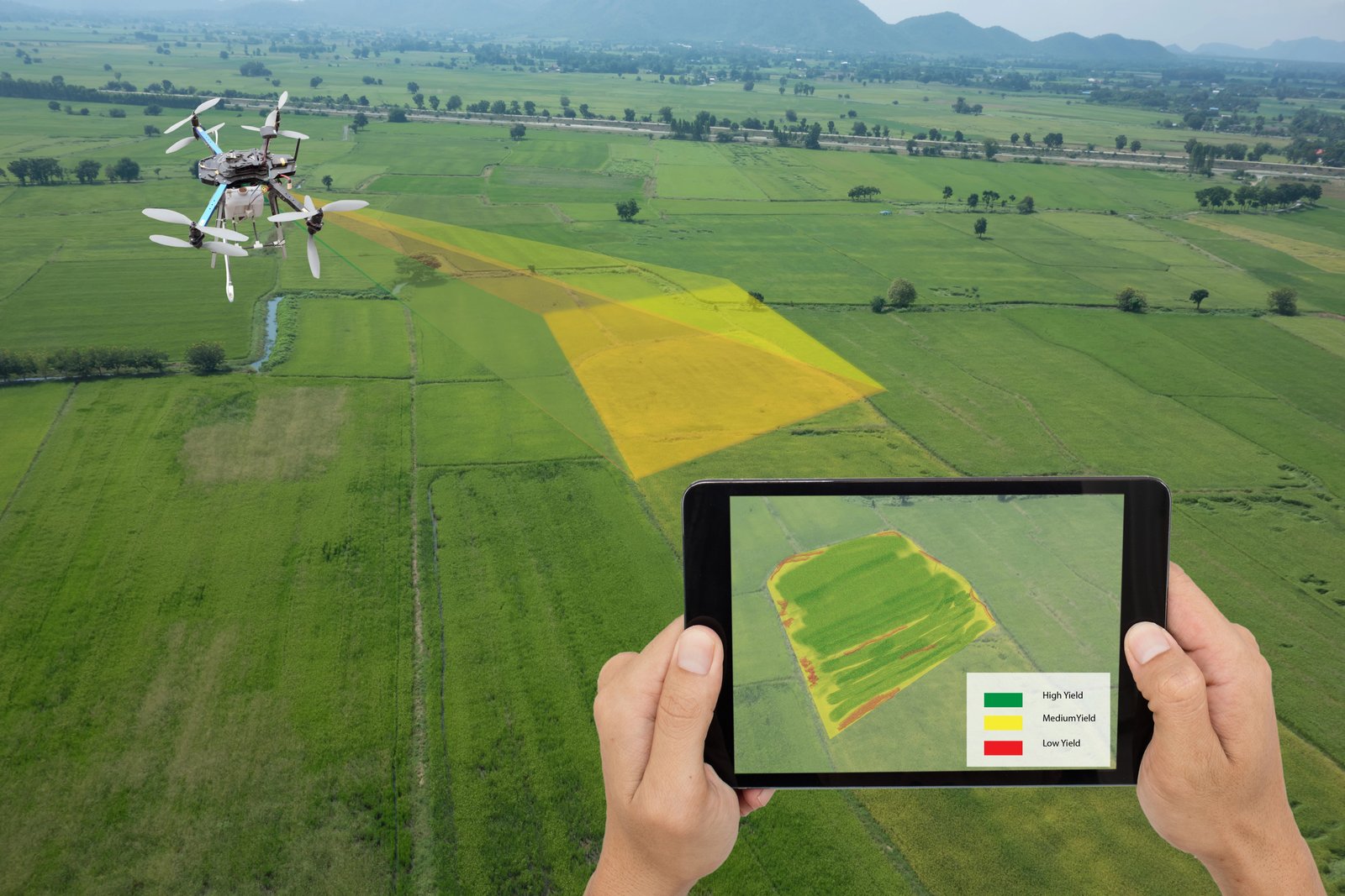
Traditional methods such as chain surveys remain relevant for small plots, offering simplicity and low cost. Geodetic or traverse surveys, using prismatic compasses, provide shape and alignment data for more complex parcels. Soil surveys classify and map soil properties, guiding crop selection and amendment strategies. Topographical surveys chart gradients, valleys, rivers, and hills, while aerial surveys—conducted via aircraft or drones—capture expansive views of vegetation, water bodies, and built structures.
The operational importance of land surveying is multifaceted. Accurate farm size measurement supports precise resource distribution. Feasibility studies assess land suitability for specific crops. Optimal land use aligns terrain and soil characteristics with cultivation plans. Farmstead planning benefits from efficient infrastructure layout. Soil classification informs sustainable management practices. Yield projections derived from survey data enhance business planning. Survey records serve as collateral for loans and insurance. Gradient analysis aids drainage and erosion control, while environmental conservation relies on high-resolution topographical data to protect waterways.
Technological advances have redefined agricultural surveying. GPS and GNSS deliver centimeter-level positioning accuracy, critical for boundary marking and large-scale mapping. Satellite imagery and remote sensing provide multispectral data for monitoring crop health, soil moisture, and vegetation indices. LiDAR systems generate detailed 3D models of terrain and structures, enabling precision drainage planning. Drone surveys offer high-resolution imagery at scale, combining speed and affordability. 3D scanning builds digital twins of landscapes and facilities for integrated planning. Soil sensors and IoT devices supply real-time property data, enhancing classification and management.
Comparative metrics highlight each method’s strengths: chain surveys achieve 80–90% accuracy at 1–2 acres per hour, GPS surveys reach 95–99% accuracy at 10–20 acres per hour, drones deliver 97–99.5% accuracy at up to 200 acres per hour, and LiDAR approaches 99.9% accuracy with detailed topography.
Seven mapping practices stand out for their impact in 2024. GPS surveying secures accurate boundaries and layouts, reducing disputes and streamlining resource allocation. Drone surveys capture rapid, repeatable data for complex landscapes, supporting timely decisions on planting and irrigation. Soil classification integrated with AI converts survey data into actionable recommendations, improving yield while minimizing waste. LiDAR and 3D mapping reveal gradients and erosion risks, informing sustainability measures. Satellite-based remote sensing detects crop stress patterns early, enabling proactive management. Comprehensive mapping data supports precision resource management, integrating fleet tracking and input usage for cost and sustainability gains. Regular topographical surveys maintain compliance and detect changes before they escalate.
Farmonaut’s platform exemplifies the integration of these technologies, combining GPS, drones, LiDAR, and AI advisory systems into accessible tools for farms of all sizes. “Modern soil management mapping can increase crop yield accuracy by up to 25% compared to traditional surveying methods,” according to the company. Certified professionals employ advanced equipment to generate reliable datasets, while smaller operations can begin with handheld GPS devices. Medium and large farms benefit from drone-based imaging, AI analysis, and cloud-based mapping platforms. Linking survey outputs to farm management systems enables real-time decision-making, compliance tracking, and traceability.
Annual or seasonal surveys are recommended to monitor land changes, prevent resource mismatches, and mitigate environmental risks. Compliance with land use and environmental regulations is facilitated by geospatial records, which also support certification processes for loans or organic trade.
For engineers, students, and enthusiasts interested in the intersection of geospatial technology and agricultural systems, the evolution of land surveying offers a compelling case study in applied precision engineering. The convergence of aerospace-derived navigation systems, robotics in the form of UAVs, and advanced sensing technologies is reshaping how farms operate, making data-driven agriculture not only possible but increasingly indispensable.